City Challenges
By 2050, 70% of the world's population will reside urban areas, and outdoor air pollution would lead to about 6.6 million premature deaths. To date, millions of people are exposed to concentrations above the limit values for the human health protection for fine particles, nitrogen dioxide, and tropospheric ozone with significant rising levels in cities since 2000s.
The successive heat waves and air pollution peaks occurred since 2000s, and COVID-19 pandemic, allowed a considerable awareness of public authorities, and have opened the door to planting strategies (greening and re-naturing cities) to mitigate the air pollution and climate change effects, enhance biodiversity, and provide recreational areas. Under the European Green Deal, the European Union commits to plant at least 3 billion additional trees in Europe by 2030.
Air Quality & Health
11.6% of deaths globally are attributed to air pollution, i.e., a total of 7 million premature deaths annually.
Policies for a cleaner urban environment

The European regulations for air quality (e.g., Air Quality Directive 2008/50/EC) and other environmental policies (e.g., EU Biodiversity Strategy 2030; EU Pollinators Initiative) commit territories and cities of at least 20,000 inhabitants to:
every
3
years
Publish their Carbon Footprint
every
5
years
Publish a Territorial Climate Air and Energy Plan
Goal
Develop an Urban Greening Plan
City Greening
Urban greening, e.g., by increasing the tree density in cities, and peri-urban greening near densely populated cities where it is not easy to plant trees, can help improve air quality and meet clean air standards in cities. The vegetation facilitates deposition of particles and gases on leaves, trunk, and branches, and absorbs gaseous air pollutants through their stomata. However, some municipalities have hurriedly planted any tree species (e.g., isoprene emitters), and these planting strategies have degraded air quality and increased asthma exacerbation.
Air pollution removal by trees strongly depends on the location, tree species, and structural characteristic of individual trees such as tree height, leaf area index, and crown diameter. To date, the air pollution removal capacity by urban trees were investigated only in a few cities by using the i-Tree Eco model (US Department of Agriculture) and municipal tree inventories. Municipalities only report their Carbon footprint through the municipal inventory of public trees
However, the municipal tree inventories, mainly based on field observations and mapped in a Geographical Information Systems, include only trees managed by the municipality which represent e.g., about 20-30% of the total number of trees. The high cost and spatial resolution of techniques, such as aerial photography and airborne laser scanning, are the main limiting factor allowing the study of individual trees.
To set up an ambitious greening plan, adapted to real needs, city planners need a suitable selection of plant species as well as a realistic tree inventory (public and private) to properly assess the role of urban green spaces in mitigating air pollution and the climate change effects in and around the cities
Our Services
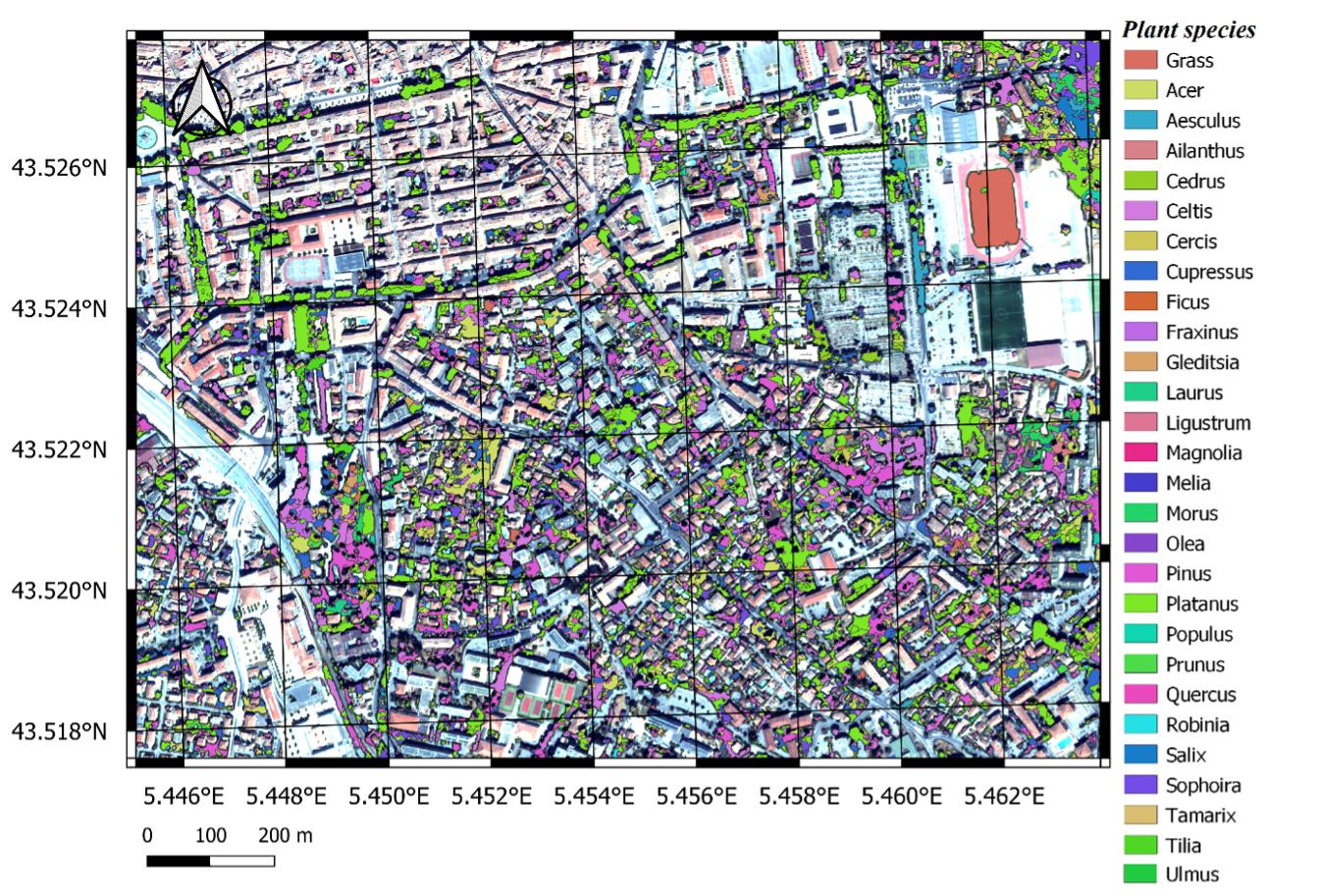
🛰️ Satellite-derived city-wide green spaces inventory
ARGANS acquires commercial Very High Resolution (VHR) satellite images, which have a spatial resolution of less than 50cm, that enables us to detect and identify individual public and private urban trees and to classify them accordingly e.g., counting, species, height, crown diameter etc
Satellite remote sensing allows us to do this for the entire city and prepare an accurate chart of green spaces within the city and a detailed inventory of the public and private individual trees, shrubs and grass.
Accurate data on location, species, and structural characteristics are essential for quantifying their benefits, however reliable information on urban vegetation in private areas and domestic gardens is lacking.
This service is billed at € 2,500 excluding tax + € 500 per square kilometer of area analyzed.
🌳 Quantifying the effects of green Spaces on air quality
Knowledge of species and characteristics of the urban greenery allows us to estimate the environmental benefits of the urban tree heritage in measurable units at the scale of the entire city.
We provide quantified estimates of carbon storage, carbon dioxide sequestration, and air pollutant removal capacity in units of tons of nitrogen dioxide, ozone, and particles per year
This service is billed at € 5,000 excluding tax + cost of the inventory
🌡️ Urban Heat Island mapping
A hybrid method to detect, monitor, and map the Urban heat island is proposed with a land classification based on the Local Climate Zones concept. VHR optical imagery are processed and associated with Landsat optical and thermal data to track temperature changes within several years and determine urban thermal comfort and sensitive areas.
This service is billed at € 300 excluding tax per square kilometer of area analyzed.
🌬️ Recommendations for clean air and greening plans
Depending on your territory and environmental conditions, ARGANS provides a list of suitable species to plant for healthier air in city, open areas available, and best practices recommendations for regreening cities (e.g., choice of plant species, number). Each tree species is assessed for its resistance to local conditions (e.g., drought tolerance, pests, and diseases), biological characteristics, and capacity to absorb air pollutants. Training of authorities in the development of Urban Greening Plans and monitoring of execution
This service costs from € 5,000 excluding tax
⚕️ Assessment of health and economic benefits
To fully appreciate the benefits of an Urban Greening Plan, ARGANS quantifies the socio-economic benefits derived from planting programs in each area: reduction in premature deaths and hospitalizations for respiratory and cardiovascular illnesses and the related costs.
This service costs from € 2,500 excluding tax.
Plus-value of such services
Incomplete municipal trees inventory counting only public trees, i.e., managed by the municipality, while public trees represent only 15% of the total number
More reliable and accurate trees inventory (private and public) accessible to local authorities - Precise data on the location, species, and structural characteristics of trees
Costly and time-consuming survey - For 5,000 public trees per km², it would take around 1000 hours of field investigation, i.e., more than 0.5-man per year per km²
Reduce manual labour by 50%
Total savings due to the service would be 30k€/year
City authorities report their carbon footprint through an inventory of trees in public areas. Such hindrance is unacceptable for a complete diagnosis of the Carbon Footprint, i.e., to complement the carbon footprint from industrial and residential sector
Precise calculation of the carbon footprint and GHGs sequestration by trees
Total savings due to the service would be 50-60k€ every 3 years.
To efficiently reduce air pollution in cities, municipalities and city planners need a suitable selection of tree species, available open areas for planting, and recommendations
Development of a suitable and fit-for-purpose re-naturing plan (e.g., EO-derived mapping of open areas available for greening strategies, EO-mapping of Urban Heat Islands, and tree species to be planted) to reach air quality standards in cities. The list of species is based on literature
Incomplete trees inventory, and these data must be transformed in mitigation effects of trees on air pollution. Some national public agencies have developed methodologies, but seldom account for air quality
Full inventory (number, species, structural characteristics of individuals)
Total savings due to the service would be 100k€ every 5 years
Clients & target users
Cities and territories of at least 20,000 inhabitants which are obligated to fulfill the national (e.g., the French Government Forum on the Environment) and European directives and regulations (e.g., Biodiversity Strategy 2030) which commit them to produce a Carbon Footprint Assessment and a Territorial Climate, Air and Energy Plan on the one hand, and on the other hand to develop an ambitious urban greening plan.
The proposed services are the result of a dozen years of preparatory works to answer national and European regulations.
ARGANS already deployed and validated the services across Europe: Aix-en-Provence (France), Florence and Milan (Italy), Valencia (Spain), Kaunas (Lithuania).
In 2019, 29 and 69 premature deaths and 189 and 416 hospital admissions could have been “avoided” by respecting the World Health Organization annual limit values in Aix and Florence, respectively.
The development of ambitious urban greening strategies, by selecting efficient plant species, can help meeting air quality standards in city.
The new reforested area (based on 400 trees) will remove annually at least 3.0 tons O3, 2.5t NO2, 1.5t PM10, 0.8t PM2.5, 10t CO2, ambient air 2°C cooler compared to surrounding area and increase carbon stocks (2t per ha). With the above air pollution reduction, 2 premature deaths and 10 hospital admissions for respiratory and cardio-vascular diseases could be “avoided” annually. Each new reforested area could prevent damages valued at €173,000 per year due to the quantity of O3, NO2, PM and CO2 removed. The new reforested area can also markedly improve quality of life of citizens by providing an area to meet others, to play sports and part of an active healthy lifestyle.

About Us
ARGANS Limited, is a fast-growing UK SME that has a reputation for excellence in delivering Earth Observation satellite remote sensing applications and services, innovative solutions in data analytics, Geographical Information Systems and the use of remote sensing data to support satellite derived bathymetry, coastal charting and mapping, climate change monitoring, environmental information, and geospatial intelligence.

Dr Sicard, is an expert on the impact assessment of air pollution and climate change on vegetation and urban forestry, with over 80 peer-reviewed publications. He is Deputy Coordinator of the RG 8.04.00 Air Pollution & Climate Change under the International Union of Forest Research Organizations (IUFRO), involved as UNECE Expert Panel on Clean Air in Cities and active in the EU Clean Air Forum.
Contact Us
Request a consultation to discuss how ARGANS might assist with your municipal greening strategy.